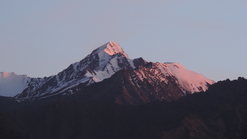
ZANSKAR - THE HARD WAY There are numbers of trekking routes in Zanskar, most of of trekking tours are from 2 weeks to 4 weeks. This is our 21st year that we are trekking and exploring Zanskar. Here we take one of the roughest & toughest hikes through the Indian Himalayas. Starting from South and finishing at the North. From the tropical south you walk through a high icy pass to warm dry gorges and deserts. We drive from Delhi to the pleasant town of Manali. Crossing Rohtang la to Urgos in the Miyar Valley. From there you walk through one of the most remote valleys past unique villages in a beautiful alpine landscape with lots of pine forests and waterfalls. Soon we walk up the Miyar glacier. This glacier is covered with debris at the beginning, but higher up is the one big ice plate, covered in the highest part with snow. From the Kang La (5450 m) we have a magnificent view. The environment consists of only sharp tops and glaciers. You descend into one of the valleys of Zanskar. Far away from everything here are some beautiful monasteries such as Bardan, Karsha and Thongde which we visit.
Our second part of trek will take us to a desolate mountain wilderness, for days we away through a maze of uninhabited canyons, wild rivers and erratic sand pillars. We cross high passes, wade through the river many times. We choose a direct route from Padum to the Indus valley, a gorgeous area where 5 passes and many river crossings await us. During this crossing we will also do the new crossing, the Shapodak La in central Zanskar. After some time in Leh enjoying the relaxed atmosphere and the many Buddhist monasteries in the area. Finally from Leh you fly back to Delhi and hometown.
OUTLINE TRIP ITINERARY
Day 01 - Arrive Delhi
Day 02 - Delhi to Manali
Day 03 - Manali
Day 04 - Manali to Rohtang la (3978 m) - Udaipur - Urgos (3250 m), 9-10 hrs jeep.
Day 05 - Trek Khanjar - Tharang (3450 m), 6-7 hrs.
Day 06 - At Tharang - acclimatization day
Day 07 - Trek Gumba nallah (3800 m), 5-6 hrs
Day 08 - Trek Palphu - foot of glacier/ moraine camp (4000 m), 6-7 hrs.
Day 09 - At moraine camp - acclimatization
Day 10 - Trek to the glacier camp (4500 m), 7 hrs.
Day 11 - Trek to glacier camp 2, ( 4900 m) 5 hrs.
Day 12 - Trek over the Kang La (5450 m) to Kanjur, 6-7 hrs.
Day 13 - Trek to Bardan Gompa (3600 m) to Padum, 5-6 hours, 1:30 hour jeep.
Day 14 - Padum rest day.
Day 15 - Padum rest day and visit to Karsha - Thongde, evening to Zangla by jeep 2 hrs.
Day 16 - Trek to Zangla Sumdo (3800 m) - Tsazar Doksa (4000m), 6-7 hrs.
Day 17 - Trek to Niri Sumdo (4420 m) Cross Pandang La (5175m), 7 hrs.
Day 18 - Trek base of Shapodak La 7-8 hrs.
Day 19 - Trek to Shapodak La (5530 m) - North base camp, 5-6 hrs.
Day 20 - Trek to North base camp to Lalung Tokpo (4050 m), 6-7 hrs.
Day 21 - Trek to Lalung Tokpo to Lapurba, 8 hrs.
Day 22 - Trek to Zalung Karpo La BC (4330 m), 5-6 hrs.
Day 23 - Trek to Zalung Karpo La BC - Zalung Karpo La (5200 m) - Tikyu (4430 m), 6-7 hrs.
Day 24 - Trek to Tikyu - Kongka Wangpo (5200 m) - Nimaling BC (5050 m), 7 hrs.
Day 25 - Trek to Nimaling BC rest
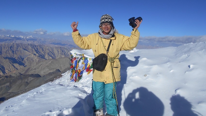
Day 26 - Ascent of Kang Yatse II (6210 m), 8-10 hrs.
Day 27 - Trek to Kongmaru La (5240 m) - Shang Sumdo (3690 m), 6-7 hrs, 2 hrs drive to Leh (3600 m)
Day 28 - Leh
Day 29 - Leh - Delhi, Delhi - home
COST INCLUDES
ü All ground transportation to & fro as per the itinerary
ü Delhi & Leh airport transfer
ü 7 nights of hotel accommodation on CP plan.
ü 20 nights camp with all camping facilities. 3 men spacious 4 season tents for 2, sleeping bags, foam mattresses, dining tent, trekking poles & safety gears.
ü All meal during trek - starts with bed tea to breakfast, lunch, 3 course dinner, tea /coffee, snacks. from Indian, Tibetan, Chinese to continental cuisine.
ü Support staff: Qualified climbing guide, cook & camp crew.
ü Trekking mules/horses for porterage of your luggage and trekking gear.
ü Camping fee, trekking permits, peak fee.
ü Goods and services tax.
ü First aid medical kit.
SIMILAR PACKAGE
Arrive
at Delhi Indira Gandhi international airport, pick up and drive to hotel. Rest
and relax.
After
an early breakfast at the hotel we drive 4-5 hours journey to Chandigarh,
watching the changing scenery roll by. Chandigarh is almost the end of the
line, located at the point where the Indian plains meet the foothills of the
Himalaya. We continue our journey into the mountains, following the Beas River
to enter the Kulu Valley, one of the most picturesque valleys in the Indian
Himalaya. The road winds its way past pine-clothed mountain slopes giving
glimpses of snow capped peaks, and through small settlements with their fields
of rice and maize and little walled orchards. Eventually, we reach the upper
part of the Kullu Valley and arrive at the popular tourist resort of Manali.
Manali is approximately 300km from Chandigarh and the journey will take us
around 7 hours. We check into hotel.
Manali
is a very popular tourist town and we will visit some of its famous sights
while we are here. We can visit the Hadimba Temple, the medieval wooden palace
at Naggar with its own art museum and enjoy a soak in the Vashisht hot springs.
It is also fun to walk around the sprawling bazaar. Manali located at an
altitude of 2040m.
Today
an early departure from Manali by jeep, we drive over to Urgos . Starting trip
from Manali, at the head of the lush green Kullu valley. The road slowly winds
up the Rohtang-la pass (3’978m.), the first of the high passes, then down into
the Lahaul valley. The landscape changes dramatically, the greenery being
replaced by barren hillsides, where the village with their bountiful fields of
barley, peas and potatoes, stand out in stark contrast. On entering Lahaul the
Buddhist influence is visible in the many monasteries crossed on the way. The
people here have distinct Tibetan features. Driving along the Chenab River. On
the way we visit famous Trilok Nath temple and Mrikula Devi temple at Udaipur.
From Udaipur follow a road, which has recently been constructed, through the
narrow gorge making the entrance to Miyar valley. Cross the wooden bridge
before Chamrat and continue on the true left bank of the valley. The village of
Chamrat is with Mani walls and prayer flags, is the first village in the Miyar
valley. Now road leads through flowered meadows and peas and millet fields to
the village of Karput. Urgos is at the confluence with the valley leading to
the Mt. Menthosa (6,443m), We prepare for the next day trek.
Leaving
Urgos we drive short distance to Shukto village and from here we trek to
Khanjar village crossing large wooden bridge. Leaving Urgos, we drive 6 kms to
Shukto village and from here we start trek to Khanjar village by crossing the
wooden bridge, across a stony moraine stretch and some side streams to Khanjar,
the last village. above the village on a beautiful alpine meadow, carpeted with
edelweiss and catmint. There are lovely pastures all along the trek up to the
camping site. The trek continues to the left side of the stream. After the last
villages of the valley we find our spacious camping pitch at Tharang. The camp
is established here.
In
this camp we stay a day to get used to the altitude better. In order to promote the acclimatization
process, we are currently exploring a side valley. We climb a few hours to
about 4200 m to the foot of the Tharang peaks.
Leaving
Tharang camp we take easy walk along the left bank of the River and walk on
vast meadows. On the way we meet shepherds with sheep, goats and yaks. They
migrate into the area in the summer to allow their cattle to graze on the
higher pastures. Tharang groups of peak 6000m appears to the sight as we walk
futher. During summer entire area is
covered with varieties of wild flowers. Arrive at beautiful camp.
Today
again along the left bank of River to the moraine camp at the foot of the
glacier (4000 m), which is also called Palphu. We walk below the castle peak.
Which is famous among the rock climbers. On the way various camping spots are
also from the Gaddi / shepherds camp known as Khai got (4100 m). You should not
just enter it because they are guarded by big black dogs (the Tibetan mastiff).
Today we leave on the early side because at the end of the day 2 tributaries
have to be crossed. Depending on the water level, that is easy or a spectacular
activity. Between large boulders there is a nice flat spot with grass to set up
your tent.
A
day for final acclimatization before taking the long Miyar glacier. This day we
ascend to Takdung glacier and below the Castle peak. We find the blue poppies,
which grows no. in during summer.
There are small lakes near the campsite, you will have opportunity to take bath
in this mountain lake.
Today
leaving camp we take on the one of longest glacier in Indian Himalaya. The
Miyar glacier is 28 kilometers long. from camp at the glacier there is choice
of route. Walk across the terminal moraine to the left side of the glacier,
route tiring ups and downs along and increasingly ill-defined trail.Demanding
terrains for the first 7/8 kms untill the confluence with a glacier flowing
from the East side, easy going from here with a gradual ascent over smooth
black ice. An occasional well exposed crevasses to negotiate. Camp just above
the confluence with the side glacier, there is 3 passes and the center one is
the actual pass. We trek on the right slopes close to the glacier and make our
way to glacier camp. We walk on loose rubbles, stones covering with ice. So it
will be hard to walk on this patch. Finally arrive at camp at an altitude of 4500m.
Leaving
camp you go to the middle of the glacier. Initially it runs easily so slowly
rising on the flat ice. Every now and then we jump over a glacier stream. To
the left and to the right you can see white glaciers shining downwards through
the black mountain walls, to the main glacier we are on. The hollow sound from
the dark caverns gives you some idea of ??how thick the ice is here. From a
certain point you can already see the pass. As we get higher there is more snow
on the ice and sometimes we have to go through a piece that is very mushy. The
going is therefore also a little more difficult. The camp lies in the middle of
the white world with a few large boulders.
An
early departure from camp. At the head of the glacier, a large snow field
curves to the East side to the base of the pass. From the camp it is still
possible to roll up for about two hours
without rope. We will stay
together now because we will soon be on the rope. 250 m ascent from the
snowfield to the pass is not hard. we put on the belts and we tie ourselves to
the rope and we do the crampons. We walk to the top of the pass in about 2
hours. Magnificent view from pass to surrounding mountains towards north and
south. We continue crossing of pass with rope up to cross crevasses, than 1.5
kms long Kang la pass enclosed by rock cliff to the north and snow walls to the
south. This Great Himalayan mountain range keep the moonsoon rain good in the
south but to the North its desert like environment. After crossing Kang la
pass, the descent continues for a large part of the day over snowfields,
sometimes steep and then sloping again.
Its 2-3 hrs to the camp. There is a beautiful campsite.
Leaving
Kanjur camp descent to Barda, we walk on the right side of the river and in the
beginning we have to wade through two fast-flowing tributaries. after crossing
the many side streams and grassy meadows, to down the valley. Arriving at rocky
plateau, trail descends steeply in places through meadows and boulder fields.
Tenasa Tokpo remains on the right bank, it flows down to a grassy meadow above
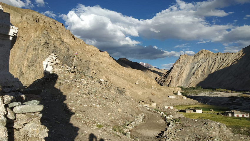
the Tsarap River, there we see Yaks grazing. Arriving a Bardan where link road
join to Padum and This is the new road between Manali and Padum that is under
construction. Only few stretch has been left to build road that is from Kurgiak
to Tsethang. We are now at about 3600 meters and in this desert and with that
bright sun it is suddenly very hot, at least when the sun is not hidden behind
clouds. Our driver will be waiting for us at here and we take short drive of
1:30 hrs to Padum. Check in hotel in Padum.
Today
full day rest, you wash clothes, take showers and explore Padum bazar and while
our crew will restock fresh vegetables and supplies for the next part of trek.
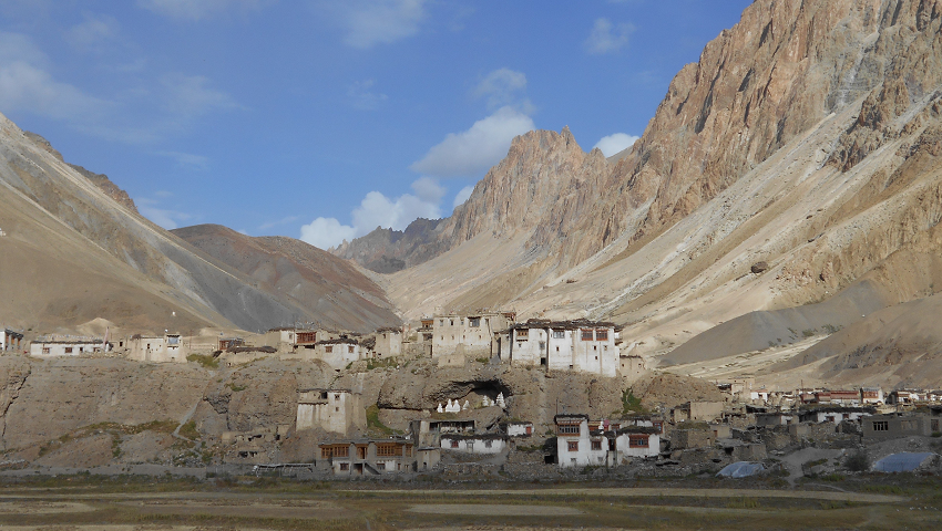
Padum,
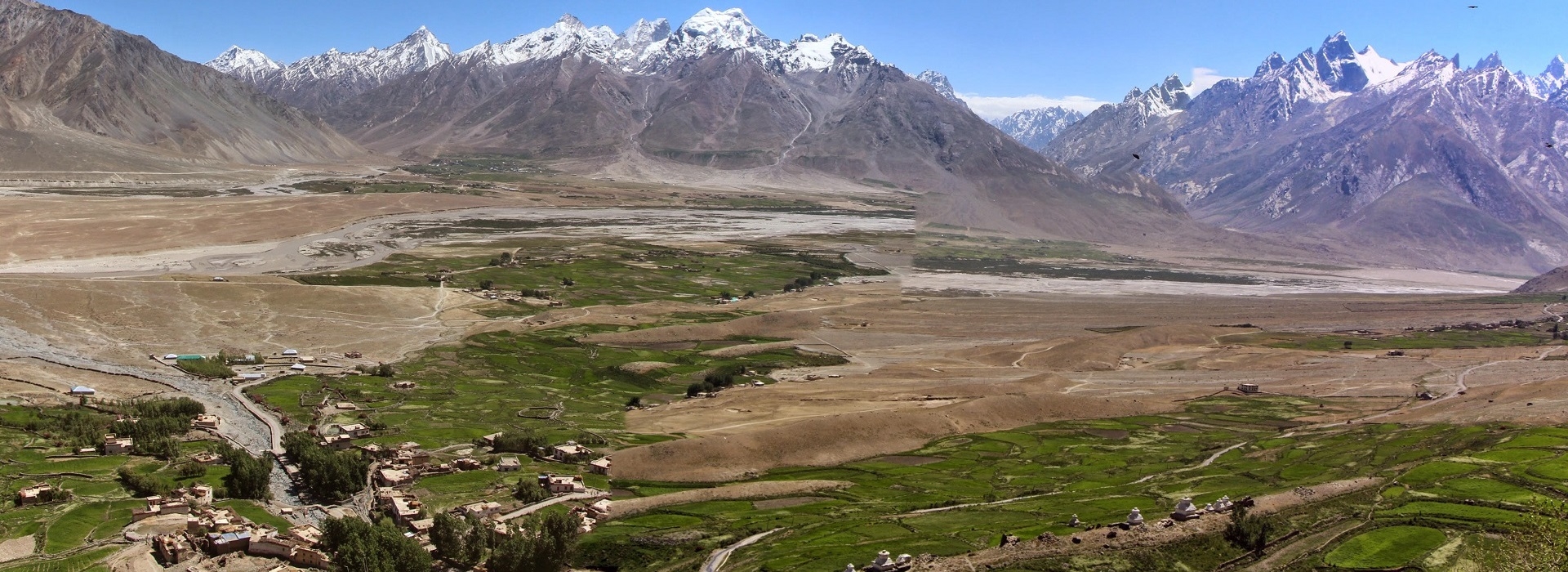
the district headquarters of Zanskar. From Padum we drive through villages and
fields to the large village of Karsha. The monastery here is the largest in
Zanskar and houses many statues and thankas (religious paintings), while its
library contains priceless ancient Buddhist manuscripts. The monastery is very
dramatically located high on the side of a cliff overlooking the fields of the
Zanskar Valley 350 metres below. If there is a festival in the monastery of
Karsha, you will witness it, if not
continue make our way to Thongde gompa.
Situated on a small ridge overlooking the valley. Finally drive to Zangla camp
which we call it Zangla River camp.
Today
after the breakfast leaving camp we walk towards the Zangla village and gradual
ascent to Zangla palace and continue along the Zangla irrigation ditch we enter
in colourful gorges known as Zangla gorge. We have to cross river again so prepare your
sandals for river crossing to reach Zangla sumdo. We continue to trek along
Zumlung Chu, which we cross many times. We pass the large sumdo where to the
left the trail leads to jumlam and Charchar la an ancient and old trade route
leading into Zanskar from Leh. The Jumlam route are mostly in active when flow
of river at its lowest volume. Arriving at Zangla sumdo where small willow tree
grows abunduntly along the river. We find our peaceful camping place between
the low bushes. This Zumlung chu crossing is only accessible from end July to
mid Sept. Thus mid Aug to mid Sept is best time. Anything before could last in
change of itinerary.
Leaving
camp the trail goes through a batch of sea buckthorn and willow bushes. The
next two hours of hiking are easy, Coming out from the willows which hides our
campsite, we now ascend gradually to Pandang la at an altitude of 5175m. We
ascend steeply on a trail of loose scree and rocks which ends at the foot of
pass and long ascent to the pass. From the pass Zanskar mountain panorama is
breathe taking and magnificent. Crossing pass its long descent to campsite.
Wild animals roams the hillside, so we open our eyes to all around. We arrive
at wonderful campsite of Niri Sumdo.
Leaving
camp after breakfast to the entrance of the valley leading to the Shapodak La.
Again the shoes go out because we have to go through the river. Then we go up
again through a narrow valley. After a few hours we stop at a place where we
know that there is no good camping place. Between the high rocks at the sound
of the rippling water, it is wonderful to sleep.
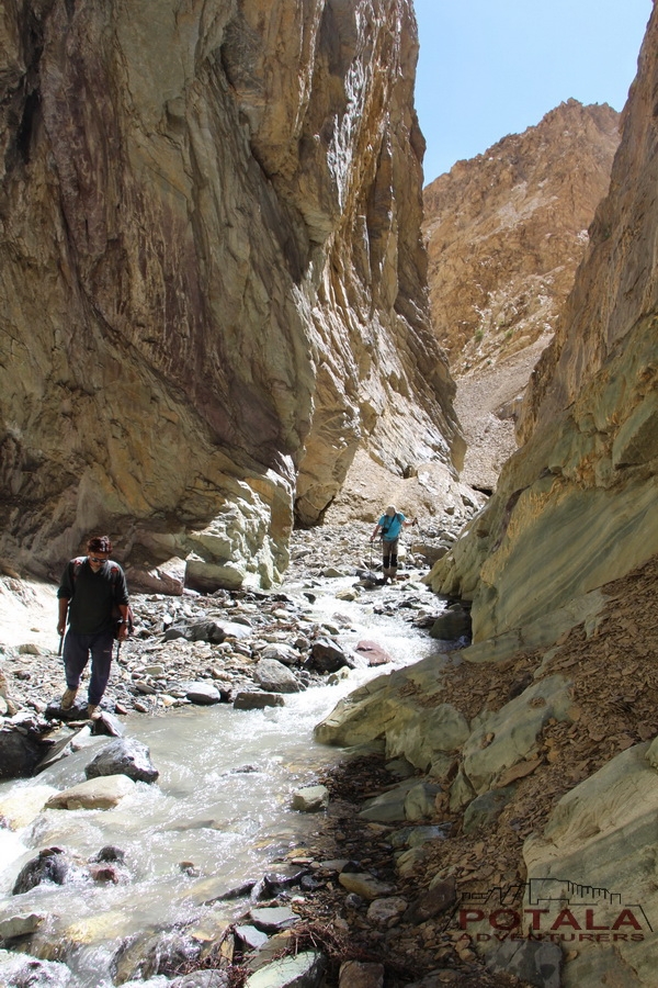
It
starts immediately with multiple crossings. The sandals go on and stay on and
nobody who counts the number of crosses still counts. We follow the river and
keep to the left. Occasionally you may wonder what we are doing because a path
is not there. But then the gap is broadened again and it is easy to do. We stop
regularly. Around the 5100 meters the valley widens with on the right a large glacier
and then suddenly left large and obviously the pass, complete with a stone man.
On the pass you have an amazing view and on the other side a surprise - a
glacier. In half an hour we descend over the glacier with ever beautiful views
to a beautiful spot on the moraine next to the glacier.
With
the crampons underneath we go up over the glacier. In half an hour we are
upstairs on the other side is also a small glacier. underneath it a nice flat grit field - a good
alternative spot. Then we descend through a narrow gorge dry riverbed with lots
of loose debris until we arrive at the main river. It is high and wild. Finally
the gap opens and a river comes from the left. Then we walk for another hour
and a half before we make the river between the bushes camp. It was a long but
spectacular day again.
After
10 minutes the sandals will go for the first crossing and they will not go out
today. The water is cold, is already fairly high and flows hard so we have to
see if you can still cross it by yourself. After 3 hours of walking and
countless crossings we are at Lapurba. Then further downstream, the wading
become more numerous and heavier, so probably together through them. it is
still spectacularly beautiful. Finally at the camp of Khurna Sumdo
From
the camp on the river we walk in an easterly direction. After about 2 hours we
arrive at a junction. To the south you follow the route to the Lar La, but we
turn to the north. After a few small river crossings we walk towards the next
pass over green grassy mountain pastures. 2 hours later we make camp with a
view of the Zalung Karpo La.
We
follow the dry riverbed to the right. It looks like a piece of dough without a
path. When we arrive there is still a path to be. Further fine path up through
the hole, then a bowl and finally the Zalung Karpo La. Again a nice view,
totally different from the previous days. In 2 hours we descend to Tikyu where
we camp.
First
to descend a little, then steadily climb along the mountainside. Maybe we see
the blue sheep that are in this area. As soon as we turn into the valley of the
pass, we have to traverse long pieces over debris . The final stretch to the
pass is steep. From here you have a beautiful view of Kang Yatze. Then to beautiful meadows up and down around
5000 meters to Nimaling. We make camp at a place where from tomorrow we can try
to climb the subtop of the Kang Yatse
Today
rest and preparation for tomorrows climb to Kang Yatse 2.
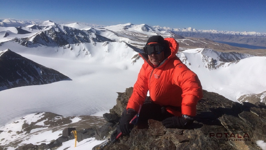
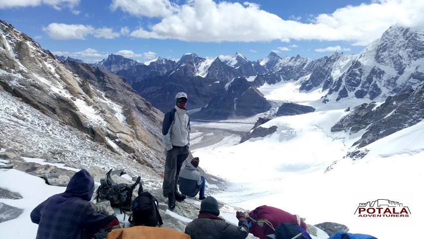
The
summit is calling. Leaving midnight early approach to the edge of Kang Yatze
II. At the snowline crampons are applied and the rise follows. Enjoy the great
view over the Markha Valley of the surrounding mountains. Descent on the
ascent route.
.
Today
leaving Nimaling, continue on path where small stream to cross then gradual
climb to the top of the highest pass of our trek, with its wonderful views from
the top as far as eye goes to all directions. On a clear sky one can see
Kangyatse, far across K2 and Karakoram Range and its peak rising above 7000m.
Soon after crossing the pass steep and long descent to Chuskirmo.
We pass the small village of Chokdo and continue along the stream to village of
Shang Sumdo. leaving Shang Sumdo, we say adieu to our horseman and drive to
Leh.
Today you enjoy your day as rest in Leh, wash clean and afternoon visit Leh bazar, Leh palace and Shanti stupa.
Morning we transfer you to airport and flight to Delhi. Arriving at Delhi airport pick and drive to hotel for few hours, before your midnight flight back to Europe or elsewhere.
Cost includes
ü All ground transportation to & fro as per the itinerary
ü Delhi & Leh airport transfer
ü 7 nights of hotel accommodation on CP plan.
ü 20 nights camp with all camping facilities. 3 men spacious 4 season tents for 2, sleeping bags, foam mattresses, dining tent, trekking poles & safety gears.
ü All meal during trek - starts with bed tea to breakfast, lunch, 3 course dinner, tea /coffee, snacks. from Indian, Tibetan, Chinese to continental cuisine.
ü Support staff: Qualified climbing guide, cook & camp crew.
ü Trekking mules/horses for porterage of your luggage and trekking gear.
ü Camping fee, trekking permits, peak fee.
ü Goods and services tax.
ü First aid medical kit.
Cost excludes
× Domestic flight Leh - Delhi.
× Hotel in Delhi.
× Travel insurance.
× Soft or hard drinks.
× Entrance fee at monasteries
× Personal tipping to staff: Guide, cook, helper, horseman, driver.
× Any unforeseen cost arises by natural hazards rain, snow, road block which cost extra lodging & boarding beyond trip Schedule.
TRIP FACTS
Activity - Trekking & hiking
Region - Himachal, Ladakh, India
Difficulty Level - Strenuous
Max Altitude - 5,530 meters
Max sleeping altitude - 4,900 meters
Lowest trek altitude - 3,250 meters
Trip Length - 29 days Delhi to Delhi
24 days Manali to Leh
21 days trekking
20 nights campinig
7 nights hotel
Best time - Mid June to mid Oct
PRICE
Price on request
DATES
Based on private booking & schedule